Territory
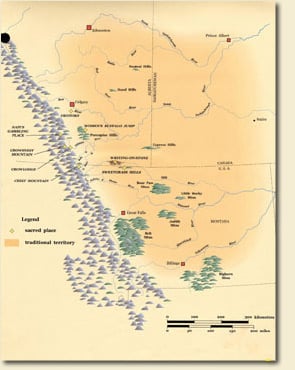 Niitsitapi traditional territory extended from the North
Saskatchewan River to the Yellowstone River in what is now southern
Montana. The
Rocky Mountains formed their western border while the eastern boundary
extended southward from the confluence of the North and South Saskatchewan
rivers.
Niitsitapi traditional territory extended from the North
Saskatchewan River to the Yellowstone River in what is now southern
Montana. The
Rocky Mountains formed their western border while the eastern boundary
extended southward from the confluence of the North and South Saskatchewan
rivers.
Some historians believe that Niitsitapi homeland was much smaller. Ted Binnema, who has written extensively about the Niitsitapi interaction with fur traders, suggests that Niitsitapi did not extend further south than the Bow River.
Hugh Dempsey, in a collection of l Niitsitapi stories, recounts Scabby Round Robe’s defeat of a “Snake” (possibly Shoshone) leader and the resulting Niitsitapi expansion south of the Bow River.
The discrepancies in defining a Niitsitapi territory reflect cultural differences in the perception of the landscape. A Western (i.e. European-base) perspective tends to look for definite boundaries which are rigorously defended. Niitsitapi perspective considers the broad distribution of resources. While clans tended to camp in favoured areas, they were well aware of places to which they could move if the local resources failed. The vast territory identified by Niitsitapi includes the entire region to which they had access for food and other resources.
![]()
![]() Next:
Contact with the Europeans
Next:
Contact with the Europeans
About the image:
Traditional
Map. The Blackfoot's traditional territory spread eastward from the
Rocky Mountains, across the northwestern plains. Courtesy of Glenbow
Museum.